 EMODnet Product Catalogue
Flanders Marine Institute
Type of resources
Available actions
Topics
Keywords
Contact for the resource
Provided by
Years
Formats
Representation types
Scale 1:
Resolution
-

EMODnet Chemistry aims to provide access to marine chemistry data sets and derived data products concerning eutrophication, ocean acidification and contaminants. The chemicals chosen reflect importance to the Marine Strategy Framework Directive (MSFD). This regional aggregated dataset contains all unrestricted EMODnet Chemistry data on contaminants (59 parameters), and covers the North Sea with 34978 CDI records divided per matrices: 3909 biota time series, 28071 water profiles, 2998 sediment profiles. Vertical profiles temporal range is from 1970-02-17 to 2017-10-26. Time series temporal range is from 1979-02-26 to 2017-02-28. Data were aggregated and quality controlled by ‘Aarhus University, Department of Bioscience, Marine Ecology Roskilde from Denmark. Regional datasets concerning contaminants are automatically harvested. Parameter names in these datasets are based on P01, BODC Parameter Usage Vocabulary, which is available at: http://seadatanet.maris2.nl/bandit/browse_step.php . Each measurement value has a quality flag indicator. The resulting data collections for each Sea Basin are harmonised, and the collections are quality controlled by EMODnet Chemistry Regional Leaders using ODV Software and following a common methodology for all Sea Regions. Harmonisation means that: (1) unit conversion is carried out to express contaminant concentrations with a limited set of measurement units (according to EU directives 2013/39/UE; Comm. Dec. EU 2017/848) and (2) merging of variables described by different “local names” ,but corresponding exactly to the same concepts in BODC P01 vocabulary. The harmonised dataset can be downloaded as ODV spreadsheet (TXT file), which is composed of metadata header followed by tab separated values. This worksheet can be imported to ODV Software for visualisation (More information can be found at: https://www.seadatanet.org/Software/ODV ). The same dataset is offered also as XLSX file in a long/vertical format, in which each P01 measurement is a record line. Additionally, there are a series of columns that split P01 terms in subcomponents (measure, substance, CAS number, matrix...).This transposed format is more adapted to worksheet applications users (e.g. LibreOffice Calc). The 59 parameter names in this metadata record are based on P02, SeaDataNet Parameter Discovery Vocabulary, which is available at: http://seadatanet.maris2.nl/v_bodc_vocab_v2/vocab_relations.asp?lib=P02 . Detailed documentation will be published soon. The original datasets can be searched and downloaded from EMODnet Chemistry Download Service: https://emodnet-chemistry.maris.nl/search
-
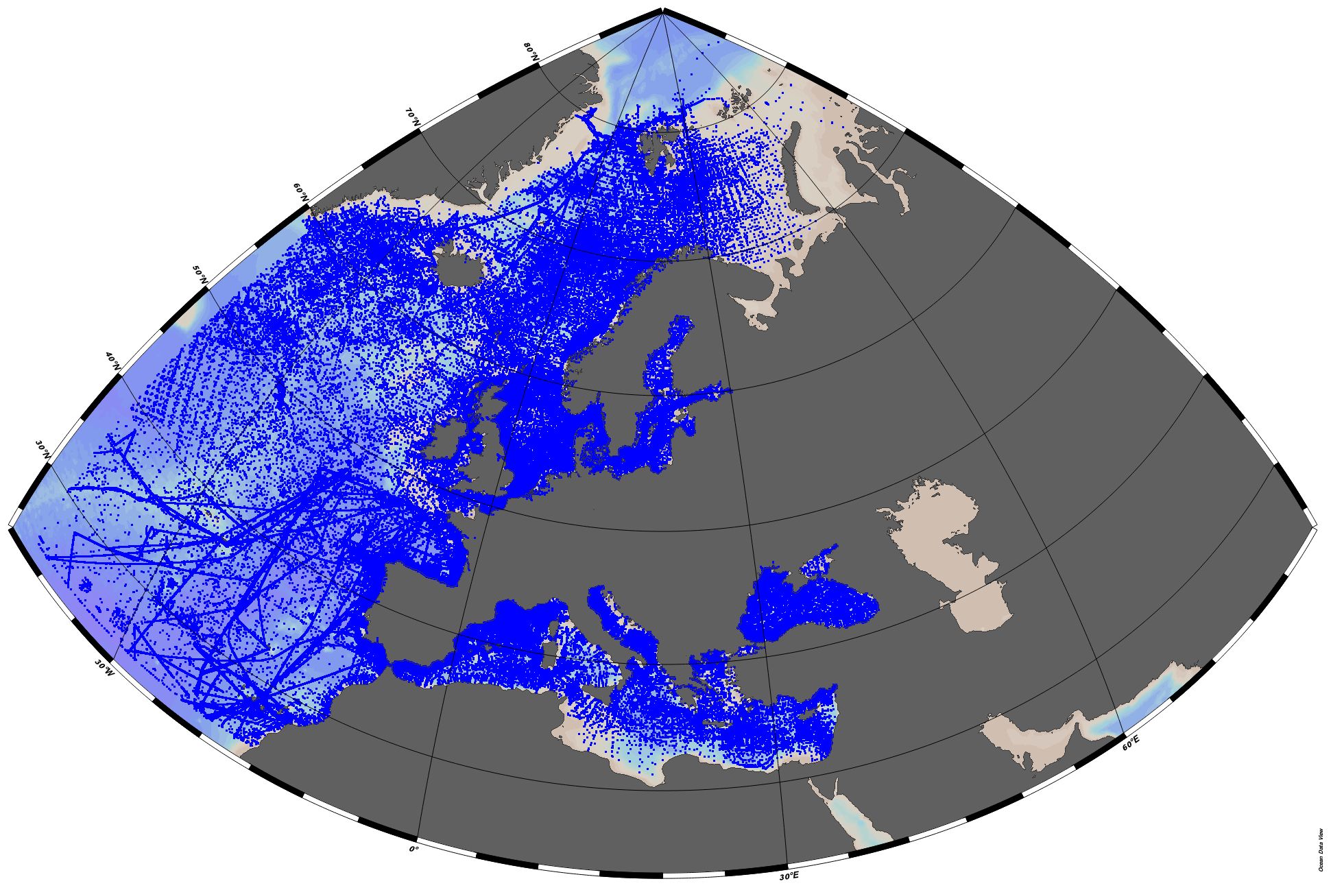
EMODnet Chemistry aims to provide access to marine chemistry datasets and derived data products concerning eutrophication, acidity and contaminants. The importance of the selected substances and other parameters relates to the Marine Strategy Framework Directive (MSFD). This aggregated dataset contains all unrestricted EMODnet Chemistry data profiles on eutrophication and acidity, and covers: the Artic Ocean, the North East Atlantic, the Greater North Sea and Celtic Seas, the Baltic Sea, the Mediterranean Sea and the Black Sea. ITS-90 water temperature and water body salinity variables have also been included ('as are') to complete the eutrophication and acidity data. If you use these variables for calculations, please refer to SeaDataNet for the quality flags: https://www.seadatanet.org/Products/Aggregated-datasets. This European dataset is the result of the aggregation of the regional datasets concerning eutrophication and acidity present in EMODnet Chemistry. The regional datasets are automatically harvested, and the resulting collections are aggregated and quality controlled using ODV Software and following a common methodology for all sea regions ( https://doi.org/10.13120/8xm0-5m67). Parameter names are based on P35 vocabulary, which relates to EMODnet Chemistry aggregated parameter names and is available at: https://vocab.nerc.ac.uk/search_nvs/P35/. This process were regionally performed by: 'Institute of Marine Research - Norwegian Marine Data Centre (NMD)' (Norway), 'IFREMER / IDM / SISMER - Scientific Information Systems for the SEA' (France), 'Aarhus University, Department of Bioscience, Marine Ecology Roskilde' (Denmark), 'Swedish Meteorological and Hydrological Institute (SMHI)' (Sweden), 'Hellenic Centre for Marine Research, Hellenic National Oceanographic Data Centre (HCMR/HNODC)' (Greece) and 'National Institute for Marine Research and Development 'Grigore Antipa' (Romania). When not present in original data, water body nitrate plus nitrite was calculated by summing all nitrate and nitrite parameters. The same procedure was applied for water body dissolved inorganic nitrogen (DIN), which was calculated by summing all nitrate, nitrite, and ammonium parameters. Concentrations per unit mass were converted to a unit volume using a constant density of 1.25 kg/L. The aggregated dataset can be downloaded as an ODV collection.
-
Coral reefs are one of the most diverse ecosystems on Earth. They are currently exposed to increasing levels of anthropogenic perturbations. Several recent reviews point to the lack of good indicators for these perturbations especially to monitor their effects on fish populations or fish assemblages. The SW lagoon of New Caledonia is an ideal location to test indicator species in this context as contrasting sites are present within a small geographical range. This study analysed fish from four sites, one with heavy industrial pollution, another dominated by domestic waste, a third with historic mining activities, and the fourth as a control. The butterfly fish, Chaetodon speculum, was chosen to determine C. speculum’s potential as an indicator species due to its link to coral, its sedentary behaviour and its wide geographical distribution. The size distribution, growth rate, age distribution and whole otolith composition were analysed at each site. Age and mean growth rate were analysed from daily increments of the otoliths. The concentrations of eight elements (Li, Mg, Co, Cu, Rb, Sr, and Ba) were measured by ICP-MS in the otoliths. The sites under anthropogenic impact were distinct from the control site by fish size frequencies, age distributions, and the chemical content of their otoliths. The chemical elements Mg, Co, Cu, and Rb showed differences amongst sites. Fish belonging to the sites furthest from Noume´a could be discriminated in nearly 80% of samples or 60% of the cases when otolith weight or fish age respectively were taken into account. Ni concentrations of the otoliths were also higher in the bays where water concentrations of this element were known to be higher, but these differences were no longer significant once corrected for otolith weight. Important Note: This submission has been initially submitted to SEA scieNtific Open data Edition (SEANOE) publication service and received the recorded DOI. The metadata elements have been further processed (refined) in EMODnet Ingestion Service in order to conform with the Data Submission Service specifications.
-
The present dataset has been used to assess how macrobenthic communities vary depending on (i) the type of dune, (ii) the position within the dune and (iii) the season. It has been combined with a biological traits dataset [Robert Alexandre Elie, Quillien Nolwenn, Bacha Mahmoud, Caulle Clémence, Nexer Maëlle, Parent Briz, Garlan Thierry, Desroy Nicolas (2021). Biological traits of macroinvertebrates associated with subtidal sandy beforms. SEANOE. https://doi.org/10.17882/80785] and results from this analysis have been published in Marine Pollution Bulletin in 2021 [Alexandre Elie Robert, Nolwenn Quillien, Mahmoud Bacha, Clémence Caulle, Maëlle Nexer, Briz Parent, Thierry Garlan, Nicolas Desroy, Sediment migrations drive the dynamic of macrobenthic ecosystems in subtidal sandy bedforms, Marine Pollution Bulletin, Volume 171, 2021, 112695, ISSN 0025-326X, https://doi.org/10.1016/j.marpolbul.2021.112695. Important Note: This submission has been initially submitted to SEA scieNtific Open data Edition (SEANOE) publication service and received the recorded DOI. The metadata elements have been further processed (refined) in EMODnet Ingestion Service in order to conform with the Data Submission Service specifications.
-
Abundance data (individuals.100 m-3) of planktonic cnidarians collected during the Camadas Finas III oceanographic cruise along the North Brazilian continental shelf between the Amazon and Oyapok river mouths and equatorial Atlantic oceanic waters between 8°N, 51°W and 3.5°S, 37°W. Data was obtained during the oceanographic cruise Camadas Finas III, aboard the research vessel NHo. Cruzeiro do Sul - H38 (DHN/Brazilian Navy), performed in 9-31 October 2012. Planktonic cnidarians were sorted from zooplankton samples collected at at 44 stations in oblique hauls, using Bongo nets with 120 and 300 µm mesh and 0.3 and 0.6 m mouth diameter, respectively. The water column was sampled from near the bottom to the surface over the continental shelf and from 200 m to the surface in the offshore. The net was towed at approximately 2 knots, at various times of day and night. Important Note: This submission has been initially submitted to SEA scieNtific Open data Edition (SEANOE) publication service and received the recorded DOI. The metadata elements have been further processed (refined) in EMODnet Ingestion Service in order to conform with the Data Submission Service specifications.
-
This dataset gathers, total abundance, abundance per size class, total biomass and biomass per size class of two vulnerable fish species, the dusky grouper, Epinephelus marginatus (Lowe, 1834), and the brown meagre, Sciaena umbra Linaeus, 1758, recorded inside and outside the Marine Natural Reserve of Scandola (Corsica, NW Mediterranean) in 2012 and 2018. Fish were recorded by underwater visual censuses performed on belt transects (50 x 15 m) run parallel to the coast between 1 and 40 m depth at 13 sites according to three levels of protection status (integral reserve, buffer zone and unprotected zone). A total of 532 transects were performed in 2012 and 526 in 2018. Image Reference: https://www.seanoe.org/data/00754/86639/illustrations/illustration-134.gif. Corsica 2012-2018-Map Scandola Marine natural Reserve Important Note: This submission has been initially submitted to SEA scieNtific Open data Edition (SEANOE) publication service and received the recorded DOI. The metadata elements have been further processed (refined) in EMODnet Ingestion Service in order to conform with the Data Submission Service specifications.
-
Aerial surveys with bird observations around the off shore wind farm Borssele (North Sea). It is acquired for gaining insight in spatio-temporal behavior of patterns of birds. RWS case number: 31163291.
-
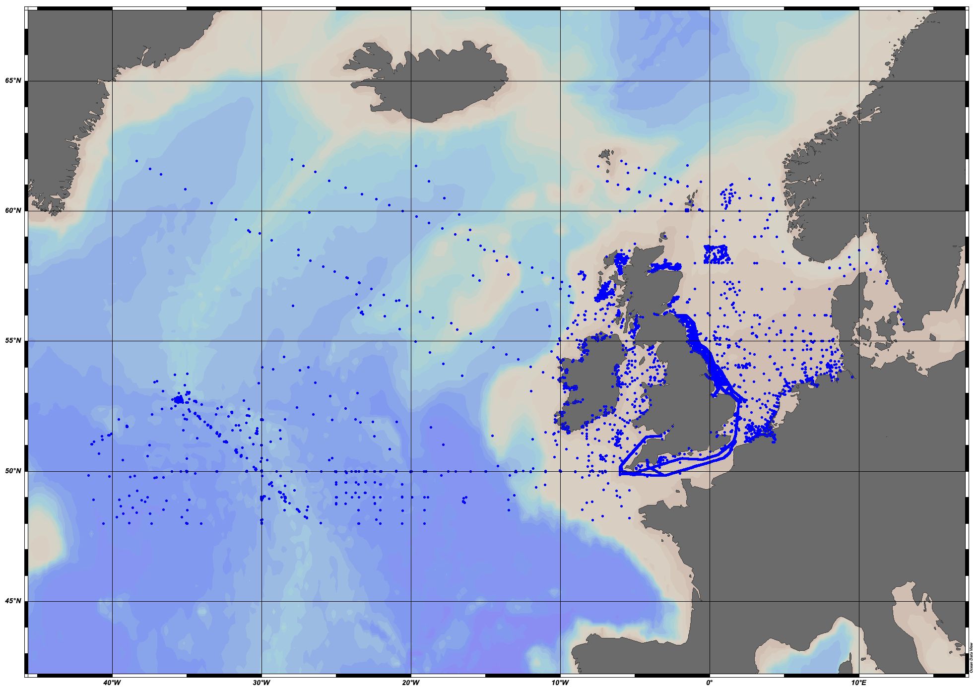
EMODnet Chemistry aims to provide access to marine chemistry datasets and derived data products concerning eutrophication, acidity and contaminants. The importance of the selected substances and other parameters relates to the Marine Strategy Framework Directive (MSFD). This aggregated dataset contains all unrestricted EMODnet Chemistry data on potential hazardous substances, despite the fact that some data might not be related to pollution (e.g. collected by deep corer). Temperature, salinity and additional parameters are included when available. It covers the Greater North Sea and Celtic Seas. Data were harmonised and validated by the 'Aarhus University, Department of Bioscience, Marine Ecology Roskilde' in Denmark. The dataset contains water (profiles), sediment (profiles) and biota (profiles and timeseries). The temporal coverage is 1970–2021 for water measurements, 1973–2021 for sediment measurements and 1979–2021 for biota measurements. Regional datasets concerning contaminants are automatically harvested and the resulting collections are harmonised and validated using ODV Software and following a common methodology for all sea regions ( https://doi.org/10.6092/8b52e8d7-dc92-4305-9337-7634a5cae3f4). Parameter names are based on P01 vocabulary, which relates to BODC Parameter Usage Vocabulary and is available at: https://vocab.nerc.ac.uk/search_nvs/P01/. The harmonised dataset can be downloaded as as an ODV spreadsheet, which is composed of a metadata header followed by tab separated values. This spreadsheet can be imported into ODV Software for visualisation (more information can be found at: https://www.seadatanet.org/Software/ODV). In addition, the same dataset is offered also as a txt file in a long/vertical format, in which each P01 measurement is a record line. Additionally, there are a series of columns that split P01 terms into subcomponents (substance, CAS number, matrix...).This transposed format is more adapted to worksheet applications (e.g. LibreOffice Calc).
-
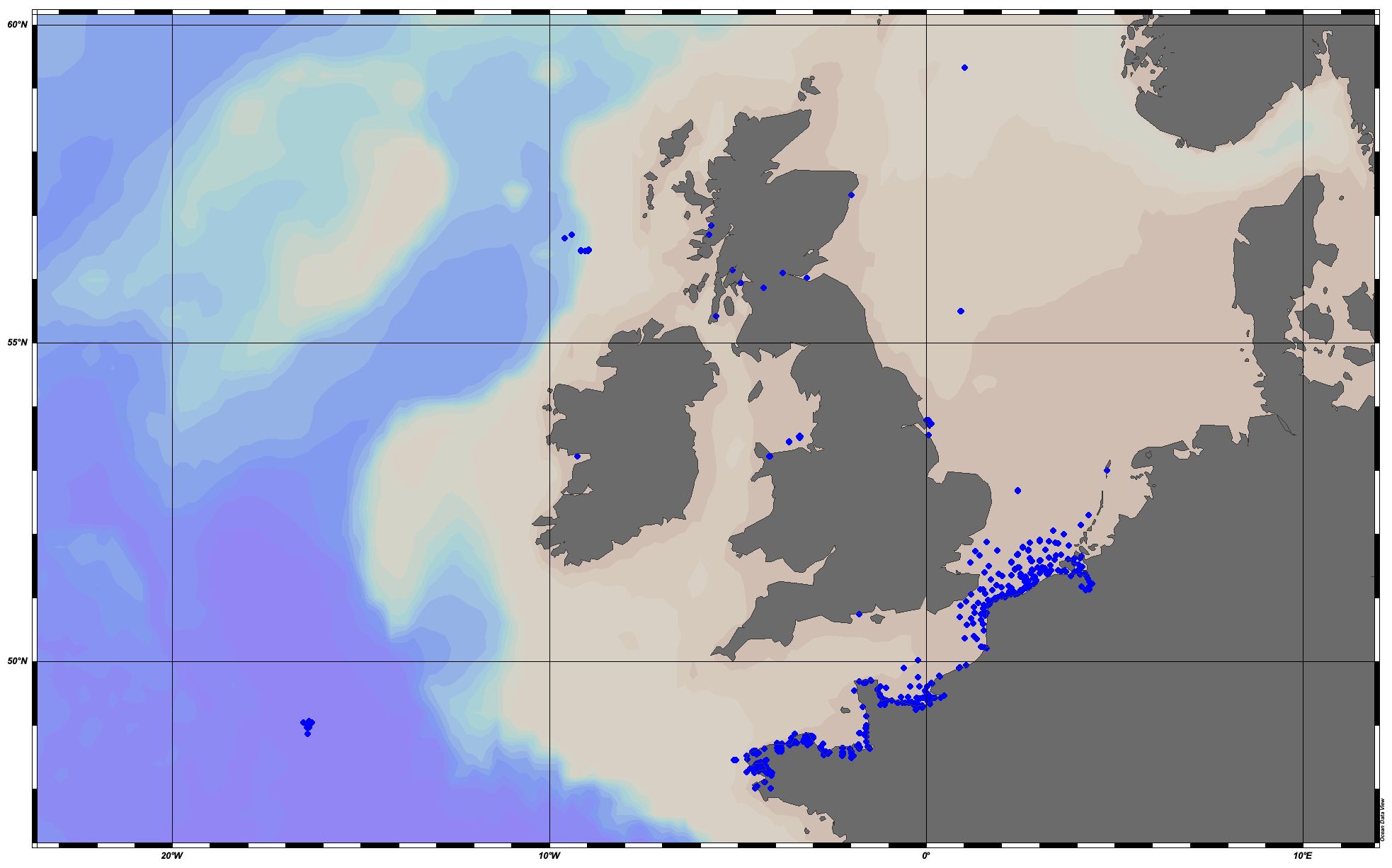
EMODnet Chemistry aims to provide access to marine chemistry datasets and derived data products concerning eutrophication, acidity and contaminants. The importance of the selected substances and other parameters relates to the Marine Strategy Framework Directive (MSFD). This aggregated dataset contains all unrestricted EMODnet Chemistry data on eutrophication and acidity, and covers the Greater North Sea and Celtic Seas. Data were aggregated and quality controlled by 'Aarhus University, Department of Bioscience, Marine Ecology Roskilde' in Denmark. ITS-90 water temperature and water body salinity variables have also been included ('as are') to complete the eutrophication and acidity data. If you use these variables for calculations, please refer to SeaDataNet for the quality flags: https://www.seadatanet.org/Products/Aggregated-datasets. Regional datasets concerning eutrophication and acidity are automatically harvested, and the resulting collections are aggregated and quality controlled using ODV Software and following a common methodology for all sea regions ( https://doi.org/10.13120/8xm0-5m67). Parameter names are based on P35 vocabulary, which relates to EMODnet Chemistry aggregated parameter names and is available at: https://vocab.nerc.ac.uk/search_nvs/P35/. When not present in original data, water body nitrate plus nitrite was calculated by summing all nitrate and nitrite parameters. The same procedure was applied for water body dissolved inorganic nitrogen (DIN), which was calculated by summing all nitrate, nitrite, and ammonium parameters. Concentrations per unit mass were converted to a unit volume using a constant density of 1.25 kg/L. The aggregated dataset can also be downloaded as an ODV collection and spreadsheet, which is composed of a metadata header followed by tab separated values. This spreadsheet can be imported to ODV Software for visualisation (more information can be found at: https://www.seadatanet.org/Software/ODV).
-
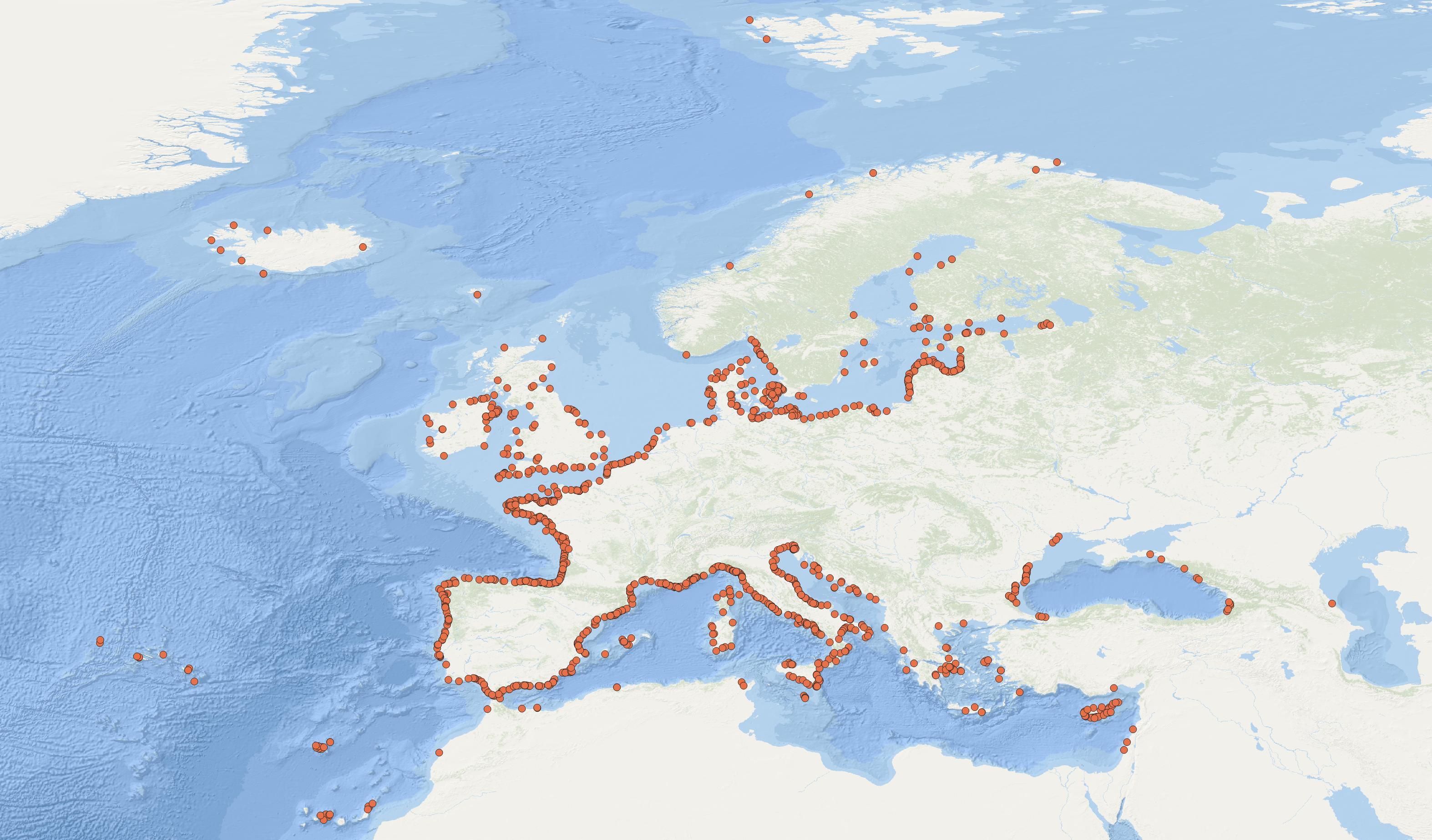
EMODnet Chemistry aims to provide access to marine chemistry data sets and derived data products concerning eutrophication, ocean acidification, contaminants and litter. The chosen parameters are relevant for the Marine Strategy Framework Directive (MSFD), in particular for descriptors 5, 8, 9 and 10. The dataset contains standardized, harmonized and validated data collections from beach litter (monitoring and other sources). Datasets concerning beach and seafloor litter data are loaded in a central database after a semi-automated validation phase. Once loaded, a data assessment is performed in order to check data consistency and potential errors are corrected thanks to a feedback loop with data originators. For beach litter, the harmonized datasets contain all unrestricted EMODnet Chemistry data on beach litter, including monitoring data, data from cleaning surveys and data from research. A relevant part of the monitoring data has been considered for assessment purposes by the European institutions and therefore is tagged as MSFD_monitoring. EMODnet beach litter data and databases are hosted and maintained by 'Istituto Nazionale di Oceanografia e di Geofisica Sperimentale, Division of Oceanography (OGS/NODC)' from Italy. Data are formatted following Guidelines and forms for gathering marine litter data, which can be found at: https://doi.org/10.6092/15c0d34c-a01a-4091-91ac-7c4f561ab508. The updated vocabularies of admitted values are available in https://nodc.ogs.it/marinelitter/vocab. The harmonized datasets can be downloaded as EMODnet Beach litter data format Version 7.0, which is a spreadsheet file composed of 4 sheets: beach metadata, survey metadata, animals and litter.